|
|
| |
 |
Fire Science |
|
|
Wildfire Monitoring and Prediction
|
|
Fire Imaging
|
|
|
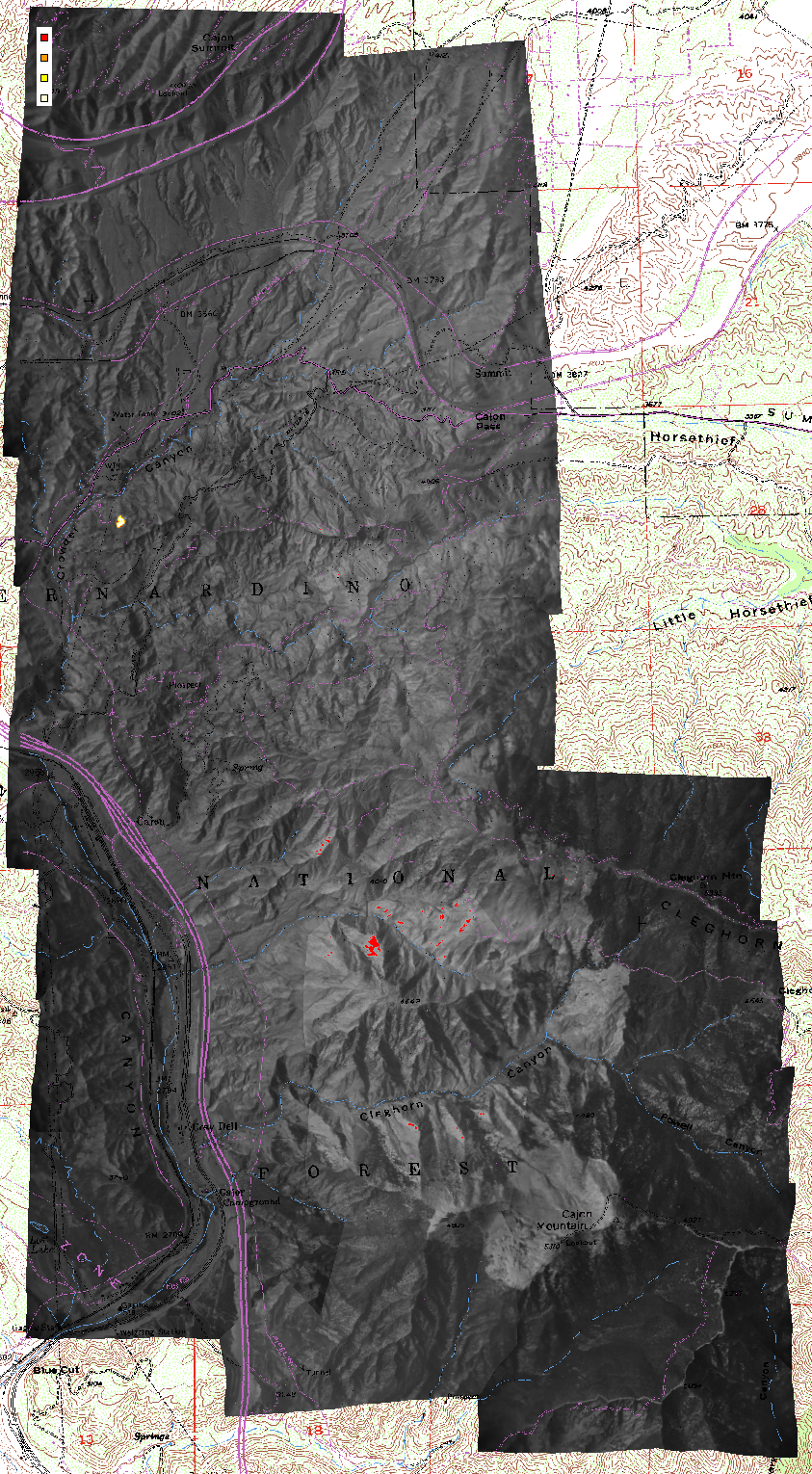
Blue Cut Fire, San Bernardino
National Forest
20 June 2002
As viewed by the FireMapper™
Thermal-Imaging Radiometer
Images were collected from the PSW Airborne
Sciences Aircraft and disseminated in part by satellite communications
in near-real time. FireMapper measures the radiance of emitted
thermal-infrared light, which readily penetrates smoke. Bright
areas shown here are very hot ground associated with active
fire fronts. Images have been geographically referenced. Vertical
exaggeration in 3-d views is 1.5 to one unless otherwise noted.
|
55 C & up
65 C & up
75 C & up
100 C & up
Blue Cut Fire as viewed from above in thermal-infrared
light (11.5 to 12.3 micrometres wavelength).
Lines in blue and purple or black are streams
and roads from topo map layer.
|
|
| |
Light gray tones are areas of ash warmed
by solar heating. Dark gray tones are unburned vegetation.
Apparent temperatures of residual burning and spot fires (red,
orange, and yellow regions) are color coded according to the
key. Active flaming combustion is shown in yellow. Latitude
and longitude of hot spots may be obtained by opening the
TIFF file in a suitable viewer such as Erdas Imagine. Ash
surface temperatures may be indicative of the severity of
burning.
|
| |
|
| |
|
After downloading a TIFF as a zip file, decompress it with WinZip
(or your favorite ZIP utility) and the TIFF will be viewable in
WangIMG or other graphics viewer. Included are the auxiliary files
necessary for proper geo-referencing (if the viewer has that capability).
Check here
to download the FREE ERDAS Viewfinder viewer.
(12 MB download; you must register before downloading).
|
|
|
|
|
| |
FireMapper™ has
been developed through a Research Joint Venture with Space Instruments,
Inc., and support from the National Fire Plan, Forest Service International
Programs, the U.S. Department of Agriculture, the Joint Fire Sciences Program, and the U.S. Agency
for International Development.
Disclaimer: Trade names, commercial products, and enterprises
are mentioned solely for information. No endorsement by the U.S. Department
of Agriculture is implied.
|