USDA Forest ServiceSkip navigational links    
 Pacific Southwest Research Station
 Pacific Southwest
Research Station
 About Us
 Contact Us
 FAQ'S
 Newsroom
 Publications & Products
 Studies
 
Recent Fires


Learn more about US-Brazil Cooperation


Learn more about US-Mexico Cooperation


Evaluate Our Service
We welcome your
comments on our customer service card

Pacific Southwest Research Station
800 Buchanan Street
West Annex Building
Albany, CA 94710-0011

(510) 883-8830

 United States Department of Agriculture Forest Service. USDA logo which links to the department's national site. Forest Service logo which links to the agency's national site.


Image Archive:

Fires
2004
2003
2002
2001

Mapping
2004
2003
2002
2001


Piper Navajo remote sensing aircraft


Fire Science

Wildfire Monitoring and Prediction


Fire Imaging -- PSW is developing new technology to monitor the progress and intensity of major wildland fires and their impacts on the environment. Remote sensing instruments now used in fire operations are nationally deployed - and thus may not be readily available to a given incident - or lack the dynamic range necessary to measure the very bright infrared light emitted from major wildfires. New technology is needed to measure the intensity and dynamics of fire fronts - properties that affect the rate of fire spread, smoke production, and forest damage - and make fire information readily and widely available.

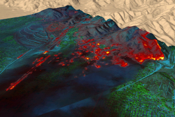
PSW is now flying the FireMapper™ thermal-imaging radiometer to map and monitor major wildfires in partnership with the Forest Service's Pacific Southwest Region. Based on modern night-vision technology, the FireMapper is designed to accurately map fire intensity and provide fire intelligence to improve firefighter safety, make fire fighting more effective, and reduce wildfire damage to natural resources and society. Imaging with the FireMapper system is also being tested for use in burned-area rehabilitation. FireMapper and associated mapping cameras are deployed aboard the PSW Airborne Sciences Aircraft, N70Z, which is a twin engine Piper Navajo.
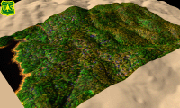
Forest Mapping -- PSW is using high-quality digital cameras (sensitive to the visible and near-infrared spectrum) to monitor forest health. Filters are employed to differentiate between the strong infrared reflectance of healthy vegetation and the strong red reflectance of dead vegetation. Diseased, stressed, or scorched vegetation has weaker infrared reflectance than healthy vegetation.

Mapping areas of dead and dying vegetation provides vital support for agencies working to assess and mitigate fire danger.


Color-coded thermal imagery depicting surface temperatures from the 2003 Old Fire, San Bernardino National Forest, as measured by the PSW FireMapper™.

False-color infrared image from the vegetation health survey in the San Bernardino National Forest, as collected by the PSW FireMapper™.

Links to Imagery


Archives of past fires: 2008 2007 2006 2005 2004 2003 2002 2001


Forest mapping: 2008 2007 2006 2005 2004 2003 2002 2001


FireMapper™ Specifications: Instrument

FireMapper™ References: Publications

FireMapper™ Tools- image analysis software: ftp downloads page

For Further Information: contact Dr. Philip J. Riggan


FireMapper™ has been developed through a Research Joint Venture with Space Instruments, Inc., and support from the National Fire Plan, Forest Service International Programs, the U.S. Department of Agriculture, the Joint Fire Sciences Program, and the U.S. Agency for International Development.

Disclaimer: Trade names, commercial products, and enterprises are mentioned solely for information. No endorsement by the U.S. Department of Agriculture is implied.
   

Disclaimers | Privacy Policy

 Last Modified: 2005-01-19