|
The SDEF comprises 6,945 ha of the Angeles National Forest in the front range of the San Gabriel Mountains north of the cities of Glendora, San Dimas, and La Verne, California. Elevation ranges from 400 meters to approx. 1,740 meters at Sunset Peak. The average slope of terrain there is 68%. The SDEF encompasses the watersheds of San Dimas and Big Dalton creeks; water conservation and flood control are provided downstream by Big Dalton and San Dimas dams which are maintained by the Department of Public Works of the County of Los Angeles.
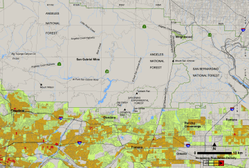
Map of population density in the SDEF region
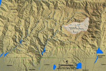
The Fern Canyon Research Natural Area occupies 555 hectares in the eastern portion of the SDEF. Only observational, non-destructive research or field experiments are permitted there. Brown’s Flat, an unusual 24-hectare meadow with relict Ponderosa Pine, is located within the RNA at an elevation of approximately 1,300 meters. Brown’s Flat was formed by a massive, pre-historic land failure.
 The The
Location map of Fern Canyon RNA in the SDEF
The field headquarters of the SDEF, located at Tanbark Flats, includes a laboratory, mess hall, residences and utility buildings that were constructed by the Civilian Conservation Corps (CCC) in the 1930s. The wooded site is adjacent to perennial Tanbark Creek. Facilities include residences, barracks, mess hall, lab/office, and various storage and utility buildings. The buildings, roads, and water diversion structures at Tanbark include some unique rockwork and architecture from the 1930s and 1940s. Tanbark Flats is also the location of the historic San Dimas Lysimeter facility which was constructed to study water use and hydrology in native plants and soils. Limited overnight accommodations and laboratory facilities are available at Tanbark for visiting researchers and scientists.
The SDEF has a Mediterranean-type climate, with cool, wet winters and hot, dry summers. Precipitation, which falls primarily from December to March, averages approximately 71 cm per year at Tanbark Flats.
A mixed Ceanothus-chamise chaparral is the predominant plant community at the SDEF. Other important types include coastal sage scrub at low elevations, California live oak (Quercus agrifolia) and riparian woodlands along canyon bottoms and streams, canyon-oak (Quercus chrysolepis) woodland on north-facing slopes at upper elevations, and scattered areas of mixed-conifer forest. Two small watersheds in Bell Canyon and areas of deeper soils on hillsides in Monroe Canyon have been "type-converted" from native chaparral to annual or perennial grassland.
Larger animals in the SDEF include black bear, mountain lion, bobcat, gray fox, southern mule deer, coyote, skunk, and raccoon. Several species of small mammals have been studied in the Forest; these include deer mice and other mouse species, kangaroo rats, wood rats, and rabbits. Populations of birds, reptiles, and amphibians have been examined.
Major wildfires have coursed portions of the SDEF in 1896, 1919, 1938, 1953, 1960, 1975, and 2002. The latest occurrence, the Williams Fire, burned over most of the SDEF 23-25 September 2002. Intermediate-size (16 to 35 hectare) watersheds in Bell Canyon and the West Fork of San Dimas Canyon were also burned under prescription in a test of the effects of fire severity in 1984. Lodi Canyon, northeast of Johnstone Peak, was similarly burned in two fires in 1986 and 1987 for fuel management and research on the smoke emissions of chaparral fire.
Continuing monitoring of precipitation, streamflow, nitrate concentration in streamwater, climate variables, and atmospheric deposition supports scientific studies in the SDEF. A station of the National Atmospheric Deposition Program (NADP/NTN) has monitored wet deposition of chemical species at Tanbark Flats since 1982. A Remote Automated Weather Station is also located there.
The SDEF is closed to the general public, except under special permit, and is therefore an ideal site to conduct ecological and hydrological field observations and scientific research. A few summer cabins remain in the lower reaches of San Dimas Canyon. No hunting, camping, hiking, bicycling, horseback riding, or other recreational activities are currently allowed in the SDEF.
|

