Plant communities:
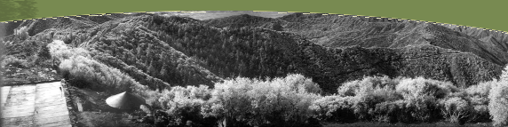
Primary plant communities on north-facing aspects are dominated by woodlands of Quercus chrysolepis and Pseudotsuga macrocarpa and chaparral comprised primarily of Quercus berberidifolia, Q. wislizenii, Heteromeles arbutifolia, and Ceanothus integerrimus. Mixed-species chaparral on south-facing aspects is dominated by Adenostoma fasciculatum with Salvia mellifera, S. leucophylla, Garrya veatchii, Arctostaphylos glandulosa, Yucca whipplei, Ceanothus crassifolius, and C. leucodermis. Riparian communities are comprised primarily of Quercus agrifolia, Alnus rhombifolia, Umbellularia californica, Platanus racemosa, and Acer macrophyllum.
Rare or Sensitive Species:
No rare or sensitive species are known to be present in the Fern Canyon RNA as of March 1999. Potential species of concern and their current status are shown in Table 1.
Climate—The climate at Fern Canyon is Mediterranean with cool, moist winters and hot, dry summers. Mean temperatures are 5.5o C in February and 23.3o C in August. Mean annual precipitation is 91cm. Light snowfall is common in winter. The RNA is subject to substantial oxidant air pollution from the Los Angeles Basin.
Facilities—Fern Canyon contains permanent facilities for stream flow monitoring, including small dams, flumes, and weirs, that were operated at the base of three small watersheds prior to 1960. A supplemental dam is located immediately downstream of the Fern triplicate-watershed dams. Streamflow was also monitored historically at a flume/weir structure at the base of Fern Canyon (Click here to view a 1941 photo of the flume). Fern Canyon was included historically in an extensive network of rain gauges measuring precipitation in mountainous terrain. A recording rain gauge is located at 5200-ft. (raingage #0202). An electronics site on the eastern edge of the RNA is managed by the ANF.
Significant features—A unique feature of the Fern Canyon RNA is Brown’s Flat, a basin-like depression formed by a prehistoric landslide. The 40-ha flat, located at an elevation of 1,310 m, drains by internal seepage and supports a shallow lake at a frequency of once in one to two decades. (Click here to view a 1940s photo of Brown's Flat when water was present). Vegetation consists of introduced and native grasses and a remnant Pinus ponderosa population comprised of approximately 40 trees. These may form the lowest-elevation naturally-occurring stand of ponderosa pine in southern California (Meier 1979). The mature pines appear to be in a state of decline, with little reproduction, possibly due to air pollution exposure or fire. Browsing by deer limits seedling survival. A small cabin was located at Brown's Flat as recently as 1902. Brown’s Flat was privately owned until 1952.
Access—Access to the Fern Canyon RNA is possible via the Sunset Ridge Truck Trail on the eastern perimeter of the RNA, via Spot B Road on the west, and via a fuelbreak along the southern boundary of the RNA. The fuelbreak and an improved trail from Sunset Ridge Truck Trail provide access to Brown’s Flat. Forest Road 1N05, which is closed to motorized traffic, leads from the Sunset Ridge Truck Trail to the triplicate-watershed dams.
Fire History—Portions of the Fern Canyon RNA have been coursed by several human-caused fires. The eastern portion was burned in the 1938 San Antonio Fire; most of the RNA was burned during the 1960 Johnstone Fire and the 1975 Village fire. The 1953 Barrett Fire burned along the southern boundary of the RNA.
Management Considerations:
The following management strategies will be applied to the Fern Canyon RNA, consistent with FS Manual direction to foster non–manipulative research and education and maintain biodiversity and natural ecological process.
Air quality impacts—Decline of stands of Pinus ponderosa due to oxidant air pollution is well documented in the San Gabriel and San Bernardino Mountains. Pseudotsuga macrocarpa is of intermediate sensitivity to air pollution but may similarly be in decline. No appropriate means of reversing a possible decline are available. Atmospheric deposition also effects high nitrate loading in streamwater in the SDEF including the RNA. No appropriate means of mitigating this impact are available.
Cultural Resources—Surveys of possible cultural resources have previously been conducted at Spot B (survey MB01) at the base of the RNA and at the Sunset Ridge electronics site (survey MB21). No features of historical or archaeological significance were noted. Further surveys will be required in conjunction with any projects involving ground disturbance. The research flumes and dams in Fern Canyon are of historical and scientific significance and should be protected. Remnants of an historic cabin may be present at Brown’s Flat.
Domestic Livestock Grazing—Livestock grazing is inappropriate and prohibited within the Fern Canyon RNA.
Fire Management—Although species in the natural communities at Fern Canyon have adaptations that allow survival in recurrent wildfires, naturally ignited fires are not common in comparison with human-caused ignitions and the current fire regime is likely one with more frequent and more severe fires than would naturally occur. Furthermore, although FSM policy allows strategies under which natural fires may be allowed to burn under prescription, this is not likely to yield a more natural fire regime. Prescribed burning is likely to entail risks to the structure of natural communities within the RNA. Thus, recognizing that neither fire exclusion nor conditions approaching a natural fire regime are possible, the management strategy will be to minimize the exposure of the RNA to fire through active fire suppression, exclusion of prescribed burning within the RNA, and management of fuels outside the perimeter of the RNA. Impacts of fire suppression will be minimized. Minimal fuel clearance will be allowed in the vicinity of the historical structures (stream gauging stations and dams) in Fern Canyon.
Fuels management will include maintenance of the existing fire break along the divide between Fern and Wolfskill Canyons (8W22), and construction of shaded fuel breaks or prescribed burning north and east of the RNA in the Upper East Fork of San Dimas Canyon and possibly on the divide between Fern and San Antonio Canyons. Prescribed burning should also be considered west of the RNA along the San Dimas main canyon or the central SDEF fuel break west of Spot B.
Fire suppression activities within the Fern Canyon RNA should be conducted in accordance with the Light Hand-Tactics Guide (FSM 2324.23.1). Specific prescriptions for minimum impact fire suppression within the RNA include the following:
1. Hand construction of lines in chaparral areas and within oak woodlands is permitted. Soil disturbance should be minimized and later repaired.
2. Use of aircraft for water drops is permitted. Retardant drops should be minimized and restricted to the perimeters of the RNA. No helispots are to be constructed within the RNA.
3. Use of heavy equipment (bulldozers) is not permitted other than on the established fuel break at the divide between Fern and Wolfskill canyons and along Sunset Ridge Truck Trail. Vehicle access for protection of resources at Brown’s Flat along this fuel break is permitted but should be minimized to prevent soil compaction and disturbance.
4. Use of pumps, chainsaws, and generators is permitted. Pruning but no felling of trees is permitted. 5. No spike camps are to be constructed within the RNA.
Post-fire rehabilitation should be restricted to prudent repair of fire breaks, trails, roads, and drainages to minimize soil erosion from direct fire suppression activities. No post-fire rehabilitation of hillsides by seeding is permitted. No reforestation will be undertaken.
Mining—The Fern Canyon area was open to prospecting prior to 1930, but no mineral deposits of value were discovered. The RNA is closed to mineral entry under the 1928 Watershed Withdrawal Act and the ANF LRMP. No mining activity of any kind is allowed.
Pest Management—Forest Service policy (FSM 4063.32) authorizes specific action against endemic insects, diseases, non-native plants, or animals if such action is necessary to protect the features for which the RNA was established or to protect adjacent resources. If practical, exotic plant or animal life should be removed. The Pinus ponderosa stand at Brown's Flat has been treated in the past for bark beetle infestations. This same area was seeded with tall wheatgrass (Agropyron elongatum) and intermediate wheatgrass (A. intermedium), both introduced species, after the Johnstone fire of 1960. No management action is contemplated at this time.
Public access—The Fern Canyon RNA has been closed by order of the Secretary of Agriculture to all types of public use except by special permit (36 CFR 251.23, FSM 4062.65). Non-motorized public access is permitted to Sunset Ridge Truck Trail at the eastern perimeter of the RNA and some use of Trail 8W22 has been authorized by permit. Occasional unauthorized access to Trail 8W22 has occurred. This unauthorized use should be monitored but is of insufficient level to warrant further action. Fern Canyon has been the site of large, illegal plantations of marijuana. Periodic surveillance by law enforcement is required to minimize these illegal incursions which otherwise may present a threat to authorized personnel.
Research access—Non-manipulative research in Forest Service RNAs by responsible scientists and educators is encouraged (FSM 4063). Educational use is restricted to individuals at upper-division college level and above. Proposals for research on the Fern Canyon RNA must be submitted to the SDEF Manager and approved by the PSW Station Director. Permits for research and education and short-term visits may be authorized by the SDEF Manager. Copies of data and reports from research within the RNA are to be transmitted to the SDEF Manager who will maintain a catalog of current studies and available publications.
Resource Protection and Law Enforcement—Forest Service policy (FSM 4063.3(1)) directs that RNAs be protected against activities that directly or indirectly modify ecological processes. Forest laws are subject to enforcement by the Angeles National Forest in coordination with other law enforcement agencies (SDEF Operating Plan, 1993). The SDEF Manager will be a point of contact with the ANF for reporting any trespass or other observed violations of forest regulations.
Roads, Facilities, and Improvements—Only roads or trails that contribute to the objectives or protection of the area are permitted within the RNA (FSM 4063.3(7), ANF LRMP). Buildings and other structures may not be constructed except as authorized by the Station Director (as per FSM 4063.31). At present the Sunset Ridge Electronics Site is managed under a special use permit by the ANF at the southeast perimeter of the Fern Canyon RNA. Forest Road 1N08 provides access there and is maintained by ANF and/or the special use permittees. The special use area predates the establishment of the RNA and presents no conflict with the RNA (RNA establishment report, 1971). The Electronic site is rigidly controlled for access, littering, encroachment into the RNA, and gate security (US Forest Service 1993).
Road 2N07 follows along the eastern perimeter of the RNA and is maintained by the ANF. Road 1N05 leads to the gauging stations on the Fern Canyon triplicate watersheds and should be maintained as trail access. Trail 1N08 to Brown’s Flat is maintained.
Threatened, Endangered, and Sensitive Species
The RNA provides wildlife habitat in minimally disturbed conditions, given the influence of occasional wildfires and urban air pollution. Manipulation of habitat strictly for wildlife enhancement is not permitted (ANF LRMP). At present there are no known populations of threatened, endangered, or sensitive species within the Fern Canyon RNA. Surveys will be conducted for the California Spotted Owl and sensitive amphibian species. If present, management guidelines for these species may affect land uses both within and adjacent to the RNA.
Timber—Logging and wood gathering are prohibited within the RNA.
Vegetation Management—Forest Service policy (FSM 4063.34, ANF LRMP) directs that vegetation management be employed only to protect and re-establish naturally occurring vegetation or natural processes. At present, any changes in the condition of plant communities in the RNA from pre-settlement conditions are unknown with the exception of possible decline in the Pinus ponderosa at Brown’s Flat and the introduction of non-native grasses and annuals there. This latter condition is common throughout southern California and the pre-settlement composition of the flora is unknown. No clear method of rehabilitation is available. No management action will be taken at this time to remove the non-native flora from Brown’s Flat.
Visual Resources—The RNA will be managed at the Preservation level of Adopted Visual Quality Objectives.
Watershed and Riparian Resources—Forest Service policy directs that water quality and quantity will be maintained at a level which represents natural conditions. No flow alterations designed to respond to off-site issues are permitted.
The RNA does include valuable facilities for measuring streamflow at the triplicate watersheds and at Spot B. The Spot B facility is derelict and not repairable without reconstruction. The triplicate watershed gauging stations are potentially usable after sediment removal from the stilling ponds. These stations should be maintained in a condition permitting reactivation. Removed sediment should be banked and stabilized.
Wildlife—Consistent with the purpose of the RNA, no manipulation of wildlife habitat for the purpose of altering populations or hunting is permitted within the RNA.
Monitoring Plan:
Ecological monitoring within the RNA will be established to document long-term ecological trends and as a baseline for judging effects of external influences, primarily those from air pollution and fire. Individual plans will describe details of monitoring methodology and responsibility. Monitoring will be undertaken in the following categories: |
