|
Williams Fire, 23-25 September 2002
Fire spread maps in 3-D
Williams Fire, 27 September 2002
Williams Fire, 26 September 2002
Williams Fire, 25 September 2002
Williams Fire, 24 September 2002
Williams Fire, 23 September 2002
Curve Fire, 7 September 2002
Curve Fire, 2 September 2002
McNally Fire, 20 August 2002
McNally Fire, 16 August 2002
McNally Fire, 15 August 2002
Pines
Fire, 10 August 2002
Pines
Fire, 7 August 2002
Pines
Fire, 3 August 2002
Pines
Fire, 2 August 2002
McNally Fire, 25 July 2002
Blue Cut Fire, 20 June 2002
Troy
Fire, 19 June 2002
Wolf Fire, 6 to 12 June 2002
Copper Fire, 7 June 2002
|
|

|
 |
Fire Science |
|
|
Wildfire Monitoring and Prediction
|
| Fire
Imaging |
|
Williams Fire, Angeles
National Forest
23-25 September 2002
As viewed by the FireMapper™
Thermal-Imaging Radiometer
Images were collected from the PSW Airborne
Sciences Aircraft and disseminated in part by satellite
communications in near-real time. FireMapper measures the
radiance of emitted thermal-infrared light, which readily
penetrates smoke. False-color images shown here depict the
apparent surface temperature (in Celsius) as estimated from
radiance and a simple black-body model. Warmer tones represent
recent or active combustion; areas of gray are cooling ash
or warm bare ground. Low temperatures of unburned forest
and cool ground are shown in green. Images have been geographically
referenced. Vertical exaggeration in 3-d views is 1.5 to
one unless otherwise noted.
|
| |
|
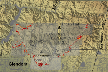
| Location Map |
Click on the image above to view a larger JPEG image
(opens a new browser window) |
| |
|
|
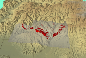
Image 1:
Ground surface temperatures as viewed from above at 11.5 to
12.3 micrometers wavelength on 23 September 2002, between
3:04 and 4:05 pm.
|
Click on the image above to view a larger JPEG image
(opens a new browser window) |
|
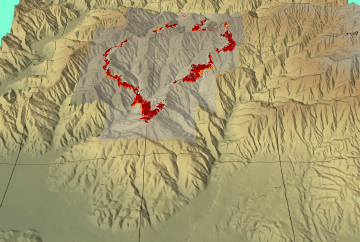
Image 1a:
Topographic view from the South of Image 1, above.
|
Click on the image above to view a larger JPEG image |
|
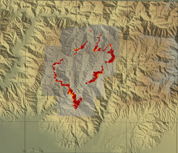
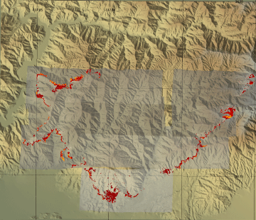
Image 2:
Ground surface temperatures as viewed from above at 11.5 to
12.3 micrometers wavelength on 23 September 2002, between
8:36 and 8:42 pm.
|
Click on the image above to view a larger JPEG image
(opens a new browser window)
|
Image 2a:
Topographic view from the South of Image 2, above.
|
Click on the image above to view a larger JPEG image
|
|
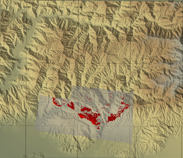
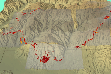
Image 3:
Ground surface temperatures as viewed from above at 11.5 to
12.3 micrometers wavelength on 24 September 2002, between
12:01 and 12:28 pm.
|
Click on the image above to view a larger JPEG image
(opens a new browser window)
|
|
Image 3a:
Topographic view from the South of Image 3, above.
|
Click on the image above to view a larger JPEG image |
| |
|
|
|
|
|
| |
FireMapper™ has
been developed through a Research Joint Venture with Space Instruments,
Inc., and support from the National Fire Plan, Forest Service International
Programs, the U.S. Department of Agriculture, the Joint Fire Sciences Program, and the U.S. Agency
for International Development.
Disclaimer: Trade names, commercial products, and enterprises
are mentioned solely for information. No endorsement by the U.S. Department
of Agriculture is implied.
|


