USDA Forest ServiceSkip navigational links    
 Pacific Southwest Research Station
 Pacific Southwest
Research Station
 About Us
 Contact Us
 FAQ'S
 Newsroom
 Publications & Products
 

Dawes Complex

30 July

>600 C

400 C

200 C

75 C

74 C

0 C


View this image of the Dawes Complex as a Google Earth overlay.


Pacific Southwest Research Station
800 Buchanan Street
West Annex Building
Albany, CA 94710-0011

(510) 559-6300

 United States Department of Agriculture Forest Service. USDA logo which links to the department's national site. Forest Service logo which links to the agency's national site.


Fire Science: Wildfire Monitoring and Prediction


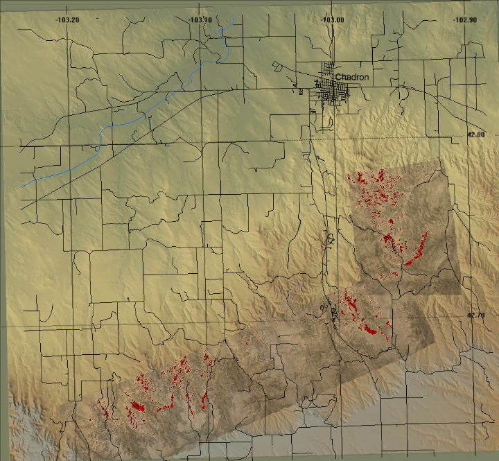
Fire Imaging: Dawes Complex
Dawes ComplexFire, Dawes County, NE
30 July 2006


As viewed by the FireMapper™ 2 Thermal-Imaging Radiometer
-data collected by the Bureau of Land Management aircraft N30W-


Click on the image above to view a larger Zoomify(JPEG) image
(opens a new browser window)

Current Image: Thermal mosaic
Ground surface temperatures as viewed from above at 11.9 micrometers wavelength on 30 July 2006, between 10:11 and 10:17 am CDT.


Archives of past fires: 2008 2007 2006 2005 2004 2003 2002 2001


Forest mapping: 2008 2007 2006 2005 2004 2003 2002 2001


FireMapper™ Specifications: Instrument

FireMapper™ References: Publications

FireMapper™ Tools- image analysis software: ftp downloads page

For Further Information: contact Dr. Philip J. Riggan


FireMapper™ has been developed through a Research Joint Venture with Space Instruments, Inc., and support from the National Fire Plan, Forest Service International Programs, the U.S. Department of Agriculture, the Joint Fire Sciences Program, and the U.S. Agency for International Development.
Disclaimer: Trade names, commercial products, and enterprises are mentioned solely for information. No endorsement by the U.S. Department of Agriculture is implied.
   

Disclaimers | Privacy Policy

 Last Modified: 2006-08-22