USDA Forest ServiceSkip navigational links    

Pacific Southwest Research Station

 Pacific Southwest
Research Station
 About Us
 Contact Us
 FAQs
 Management Plans
 Newsroom
 Publications & Products
 Researchers & Cooperators
 Studies

Research Topics

 Air Quality
 Ecosystem Processes
 Fire Science
 Insects & Disease
 Recreation
 Urban Forestry
 Vegetation Management
 Water & Watersheds
 Wildlife & Fish

Programs & Projects

Research Centers

Evaluate Our Service

Pacific Southwest Research Station
800 Buchanan Street
West Annex Building
Albany, CA 94710-0011

(510) 559-6300


View the SDEF raingauges in Google Earth or in Google Maps.
Locations approximate.

San Dimas Experimental Forest

SDEF Home Page | Williams Fire | Fire Severity | Fire Emissions | Water Quality | Water Yield | Ecology | Lysimeters | Resources & Maps | Photos | Management Plan | Site description, Facilities, and Use | The Future of San Dimas

Maps of the San Dimas region:

Map of the San Dimas region

Click on the thumbnail to the left to view the full-resolution image.

Map of the San Gabriel region

Click on the thumbnail to the left to browse the full-resolution image.

Shaded relief map of the San Dimas region, derived from 10-meter DEM data.

Click on the thumbnail to the left to browse the full-resolution image.

Click on this link to download the original DEM data in ASCII DEM format (11 MB ZIP file).

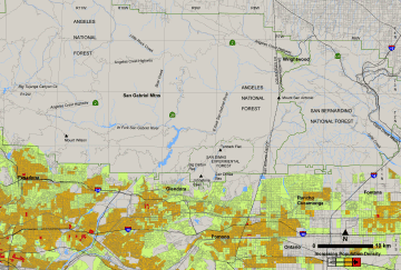
1:24,000 topo map of the San Dimas region, spliced together from the Mt. Baldy and Glendora quads. 1.5 m pixel size, UTM NAD 27 projection.

Click on the thumbnail to the left to browse the full-resolution image.

Click on this link to download the image in geoTIFF format (11 MB ZIP file).


Disclaimers | Privacy Notice | Web Manager

Last Modified: October 14, 2004