USDA Forest ServiceSkip navigational links    
 Pacific Southwest Research Station
 Pacific Southwest
Research Station
 About Us
 Contact Us
 FAQ'S
 Newsroom
 Publications & Products


Pacific Southwest Research Station
800 Buchanan Street
West Annex Building
Albany, CA 94710-0011

(510) 559-6300

 United States Department of Agriculture Forest Service. USDA logo which links to the department's national site. Forest Service logo which links to the agency's national site.
   

>700 C

500 C

300 C

85 C

60 C

<60 C


Piper Navajo remote sensing aircraft

Fire Science: Wildfire Monitoring and Prediction


Fire Imaging: Troy Fire
   
Troy Fire, Cleveland National Forest
19 June 2002
and 20 June 2002


As viewed by the FireMapper™ Thermal-Imaging Radiometer

Images were collected from the PSW Airborne Sciences Aircraft and disseminated in part by satellite communications in near-real time. FireMapper measures the radiance of emitted thermal-infrared light, which readily penetrates smoke. False-color images shown here depict the apparent surface temperature (in Celsius) as estimated from radiance and a simple black-body model. Warmer tones represent recent or active combustion; areas of gray are cooling ash or warm bare ground. Low temperatures of unburned forest and cool ground are shown in green. Images have been geographically referenced.


NEW!
Flash movies added


Got Flash?
Get it here: http://www.macromedia.com/software/flashplayer


Base Image

3-band image is visible red band, NIR band and TIR band image of fire area on 20 June.

Ash layer is magenta area in center of image. Smoke from residual burning is seen in the eastern portion of the image.


Click on the image above to view a larger JPEG image
 

Base Image in 3D perspective view

Ash layer is magenta area in center of image. Smoke from residual burning is seen in the eastern portion of the image.


View Troy Fire image as Google Earth overlay


Click on the image above to view a larger JPEG image
 

View movie with all images in sequence.
Macromedia Flash movie
 

View slideshow with all images in sequence.
Zoomify slideshow


View slideshow of 3D post-fire terrain; perspective view from the west.
Zoomify slideshow


View slideshow of 3D post-fire terrain; perspective view from the east.
Zoomify slideshow


View slideshow of 3D post-fire terrain; perspective view from the south.
Zoomify slideshow


Links


Archives of past fires: 2008 2007 2006 2005 2004 2003 2002 2001


Forest mapping: 2008 2007 2006 2005 2004 2003 2002 2001


FireMapper™ Specifications: Instrument

FireMapper™ References: Publications

FireMapper™ Tools- image analysis software: ftp downloads page

For Further Information: contact Dr. Philip J. Riggan


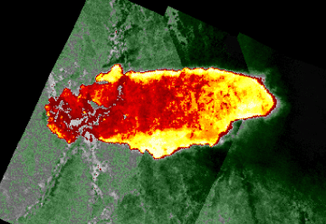
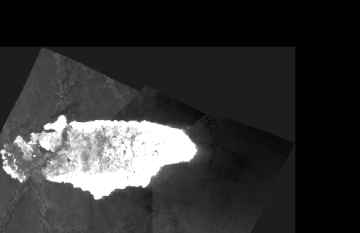
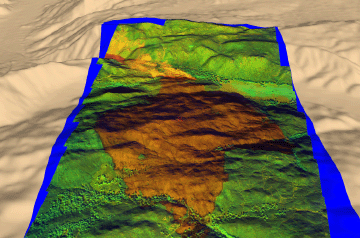
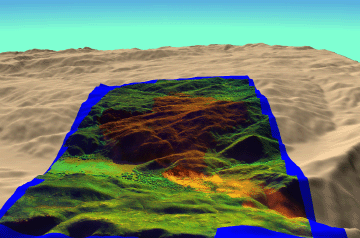
FireMapper™ has been developed through a Research Joint Venture with Space Instruments, Inc., and support from the National Fire Plan, Forest Service International Programs, the U.S. Department of Agriculture, the Joint Fire Sciences Program, and the U.S. Agency for International Development.
Disclaimer: Trade names, commercial products, and enterprises are mentioned solely for information. No endorsement by the U.S. Department of Agriculture is implied.

Disclaimers | Privacy Policy

 Last Modified: 2009-07-21