Bridge
Fire, San Bernardino NF
5 September 2003
As viewed by the FireMapper™
Thermal-Imaging Radiometer
Images were collected from the PSW Airborne
Sciences Aircraft and disseminated in part by satellite
communications in near-real time. FireMapper measures the
radiance of emitted thermal-infrared light, which readily
penetrates smoke. False-color images shown here depict
the apparent surface temperature (in Celsius) as estimated
from
radiance and a simple black-body model. Warmer tones represent
recent or active combustion; areas of gray are cooling
ash
or warm bare ground (see chart below). Low temperatures
of unburned forest and cool ground are shown in green.
Images have been geographically referenced. Vertical exaggeration
in 3-d views is 1.5 to one unless otherwise noted.
|
| |
|
Location Map
Bridge fire (courtesy of
wildfire.cr.usgs.gov/ca_geomac). Active fires are labeled in
white. |
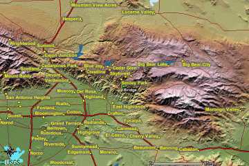
Click on the image above to view a larger JPEG image |
Fire Map
|
|
Click on the image above to view a larger JPEG image
(opens a new browser window) |
| |
Fire Imagery
|
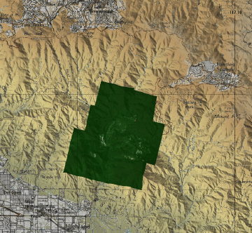
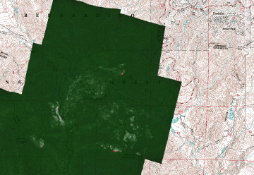
The following color-coded images depict apparent ground surface temperatures
in Celsius. Roads, streams, and the text in the background are from
a 1:24,000 topographic map.
|
| |
|
|
Image 1:
Ground surface temperatures as viewed from above at 11.9
micrometers wavelength on 6 September 2003, between 1:10
and 1:23 AM PDT.
|
Click on the image above to view a larger JPEG image |
|
|
|
|
Image 2:
Image from above, on a shaded relief map.
|
Click on the image above to view a larger JPEG image |
|
|
|
Image 3:
Topographic view as seen from the northwest of Image 1.
|

Click on the image above to view a larger JPEG image |
| |
|
|
|
Narrative
from the INCIDENT MANAGEMENT SITUATION REPORT
SATURDAY SEPTEMBER 6, 2003 - 0800 MDT. (Courtesy of www.nifc.gov.) |
BRIDGE, San Bernardino National
Forest. A unified command between a Type 2 Incident
Management Team (Domanski), Running Springs Fire District and
San Bernardino County Fire
Department is in place. The fire is in grass and brush, with
a timber component in the upper
reaches of the watershed. The fire is threatening areas with
medium to high timber and vegetation
mortality, many of which have high structure density in the
urban interface. Highway 18 is closed
between Sky Forest and Big Bear dam, and only residents are
being allowed through at this time.
Highway 330 is closed from Live Oak at the tip to Highland
at the bottom. There are mandatory
evacuations in the communities of Smiley Park, Oak Knob, Running
Springs, Arrowbear, Nob Hill,
Enchanted Forest, and Fredalba. Structure protection is in
place for 1,500 residences. |
|
|
 Piper Navajo remote sensing aircraft


