Beta Lake, Flathead
County, MT
20 August 2003
As viewed by the FireMapper™
Thermal-Imaging Radiometer
Images were collected from the PSW Airborne
Sciences Aircraft and disseminated in part by satellite
communications in near-real time. FireMapper measures the
radiance of emitted thermal-infrared light, which readily
penetrates smoke. False-color images shown here depict
the apparent surface temperature (in Celsius) as estimated
from
radiance and a simple black-body model. Warmer tones represent
recent or active combustion; areas of gray are cooling
ash
or warm bare ground (see chart below). Low temperatures
of unburned forest and cool ground are shown in green.
Images have been geographically referenced. Vertical exaggeration
in 3-d views is 1.5 to one unless otherwise noted.
|
| |
|
Location Map
Beta Lake fire (courtesy of
www.geomac.gov). Active fires are labeled in white. |
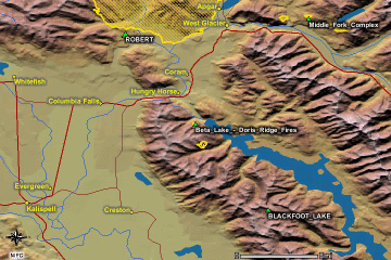
Click on the image above to view a larger JPEG image |
| |
|
Fire Imagery
|
The following color-coded images depict apparent ground surface temperatures
in Celsius. Roads, streams, and the text in the background are from
a 1:24,000 topographic map.
|
| |
|
| Image 1:
Ground surface temperatures as viewed from above at 11.9
micrometers wavelength on 20 August 2003, at 21:31 UMT.
|
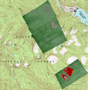
Click on the image above to view a larger JPEG image |
|
Image 2:
Topographic view as seen from the northeast of Image 1.
|
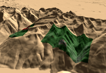
Click on the image above to view a larger JPEG image |
Image 3:
Topographic view as seen from the southeast of Image 1. |
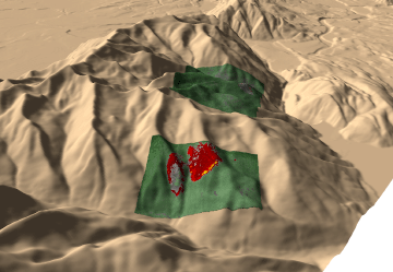
Click on the image above to view a larger JPEG image |
|
|
|
| |
|
| |
|
Narrative
from the INCIDENT MANAGEMENT SITUATION REPORT
FRIDAY AUGUST 22, 2003 - 0530 MDT. (Courtesy of www.nifc.gov.) |
|
BETA LAKE – DORIS RIDGE, Flathead National
Forest. A Type 1 Incident Management Team
(Ferguson) is assigned. These fires are in timber, five miles
south of Hungry Horse, MT. The fires
are in close proximity to the Hungry Horse Dam, recreational
and communication facilities and
powerlines. Fire behavior was limited to ground fire and
isolated torching.
|
 Piper Navajo remote sensing aircraft


