Northeast line
Cooney Ridge Fire, Missoula, Ravalli, and Granite Counties,
MT
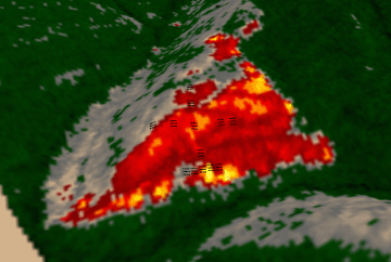
3 September 2003
As viewed by the FireMapper™ Thermal-Imaging
Radiometer
Images were collected from the PSW Airborne
Sciences Aircraft and disseminated in part by satellite
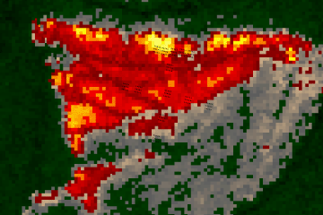
communications in near-real time. FireMapper measures the
radiance of emitted thermal-infrared light, which readily
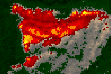
penetrates smoke. False-color images shown here depict
the apparent surface temperature (in Celsius) as estimated
from radiance and a simple black-body model. Warmer tones
represent recent or active combustion; areas of gray are
cooling ash or warm bare ground (see chart below). Low
temperatures of unburned forest and cool ground are shown
in green. Images have been geographically referenced.
|
| |
|
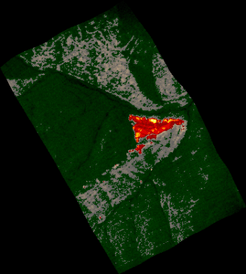
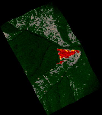
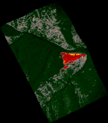
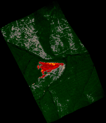
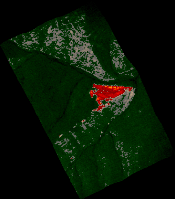
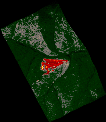
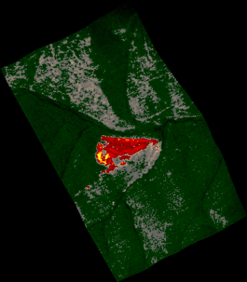
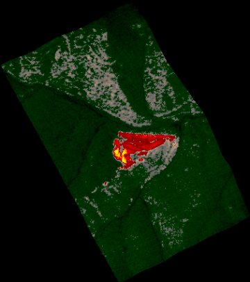
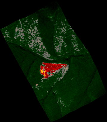
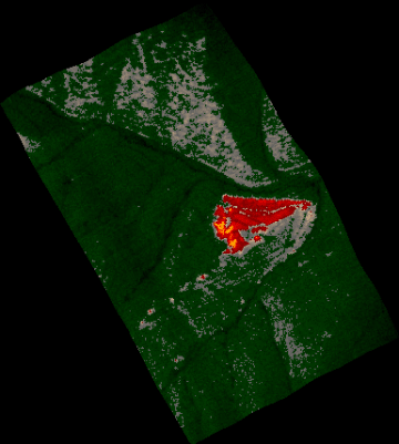
Location Map
Area of Cooney Ridge fire
|

Click on the image above to view a larger JPEG image |
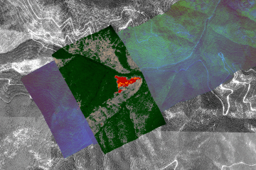
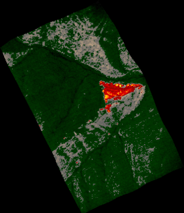
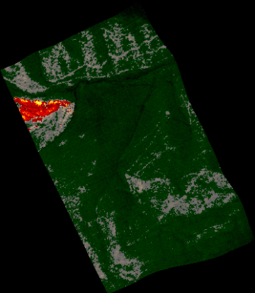
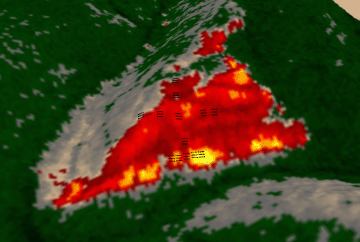
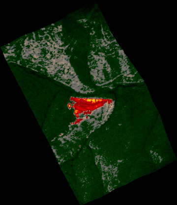
Fire Experiment Area Image
Area of Joint Fire Science Program experiment.
(This RGB image depicts reflected red light at 650 nm in blue, reflected near-IR
light at 850 nm in green, and emitted thermal-IR light at 10.5 um in red.)
Link
to Imagine .img format file
Link
to geoTIFF .zip file
|
Click on the image above to view a larger JPEG image |
Fire Imagery
|
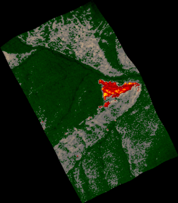
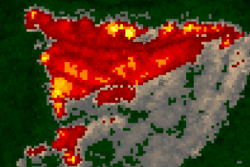
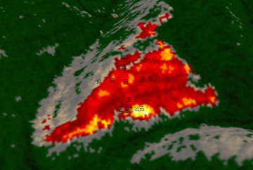
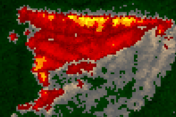
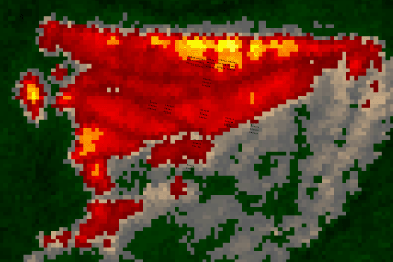
The following color-coded images depict apparent ground
surface temperatures in Celsius. The background image
is from the NAPP aerial photography dataset.
They were collected as part of coordinated ground-based
and
airborne observations of fire behavior.
|
| |
|
|
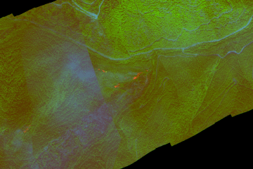
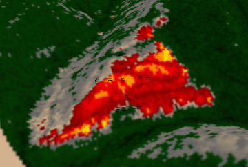
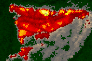
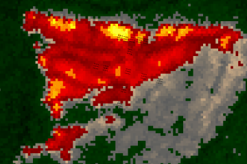
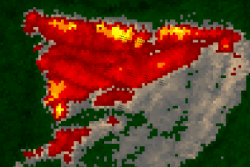
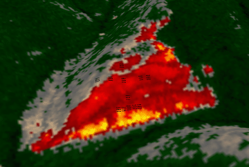
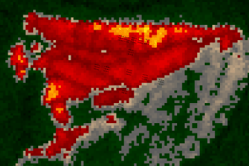
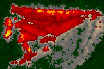
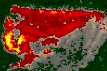
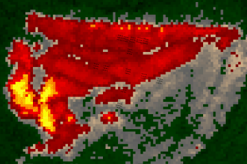
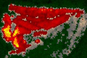
Image 1:
Thermal image over visible
and near-IR bands from an earlier transect.
|
Click on the image above to view a larger JPEG image |
| |
|
|
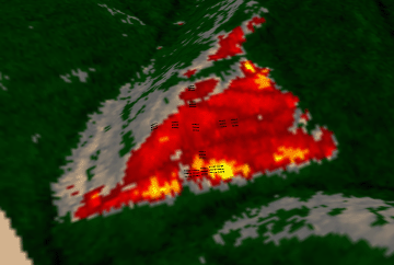
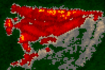
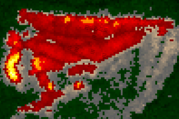
Image 1a:
Ground surface temperatures as viewed from above at 11.9 micrometers wavelength
on 3 September 2003, at 15:46 MDT.
15 foot pixel size
Link
to Imagine .img format file
Link
to geoTIFF .zip file
|
Click on the image above to view a larger JPEG image |
|
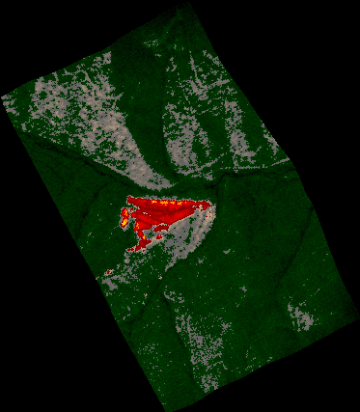
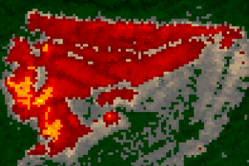
Image 1b:
Approximate plot locations shown as black squares.
|
Click on the image above to view a larger JPEG image |
|
Image 1c:
Topographic view from the northeast. Plots are shown as black squares.
|
Click on the image above to view a larger JPEG image |
|
Image 2:
Ground surface temperatures as viewed from above at 11.9 micrometers wavelength
on 3 September 2003, at 15:50 MDT.
15 foot pixel size
Link
to Imagine .img format file
Link
to geoTIFF .zip file
|
Click on the image above to view a larger JPEG image |
|
Image 2a:
Approximate plot locations shown as black squares.
|
Click on the image above to view a larger JPEG image |
|
Image 2b:
Topographic view from the northeast. Plots are shown as black squares.
|
Click on the image above to view a larger JPEG image |
|
Image 3:
Ground surface temperatures as viewed from above at 11.9 micrometers wavelength
on 3 September 2003, at 15:54 MDT.
15 foot pixel size
Link
to Imagine .img format file
Link
to geoTIFF .zip file
|

Click on the image above to view a larger JPEG image |
|
Image 3a:
Approximate plot locations shown as black squares.
|
Click on the image above to view a larger JPEG image |
|
Image 3b:
Topographic view from the northeast. Plots are shown as black squares.
|
Click on the image above to view a larger JPEG image |
|
Image 4:
Ground surface temperatures as viewed from above at 11.9 micrometers wavelength
on 3 September 2003, at 15:56 MDT.
15 foot pixel size
Link
to Imagine .img format file
Link
to geoTIFF .zip file
|
Click on the image above to view a larger JPEG image |
|
Image 4a:
Approximate plot locations shown as black squares.
|
Click on the image above to view a larger JPEG image |
| |
|
|
Image 5:
Ground surface temperatures as viewed from above at 11.9 micrometers wavelength
on 3 September 2003, at 16:00 MDT.
15 foot pixel size
Link
to Imagine .img format file
Link
to geoTIFF .zip file
|
Click on the image above to view a larger JPEG image |
|
Image5a:
Approximate plot locations shown as black squares.
|
Click on the image above to view a larger JPEG image |
|
Image 5b:
Topographic view from the northeast. Plots are shown as black squares.
|
Click on the image above to view a larger JPEG image |
|
Image 6:
Ground surface temperatures as viewed from above at 11.9 micrometers wavelength
on 3 September 2003, at 16:05 MDT.
15 foot pixel size
Link
to Imagine .img format file
Link
to geoTIFF .zip file
|
Click on the image above to view a larger JPEG image |
|
Image6a:
Approximate plot locations shown as black squares.
|
Click on the image above to view a larger JPEG image |
|
Image 6b:
Topographic view from the northeast. Plots are shown as black squares.
|
Click on the image above to view a larger JPEG image |
|
Image 7:
Ground surface temperatures as viewed from above at 11.9 micrometers wavelength
on 3 September 2003, at 16:15 MDT.
15 foot pixel size
Link
to Imagine .img format file
Link
to geoTIFF .zip file
|
Click on the image above to view a larger JPEG image |
|
Image 7a:
Approximate plot locations shown as black squares.
|
Click on the image above to view a larger JPEG image |
|
Image 7b:
Topographic view from the northeast. Plots are shown as black squares.
|
Click on the image above to view a larger JPEG image |
|
Image 8:
Ground surface temperatures as viewed from above at 11.9 micrometers wavelength
on 3 September 2003, at 16:20 MDT.
15 foot pixel size
Link
to Imagine .img format file
Link
to geoTIFF .zip file
|
Click on the image above to view a larger JPEG image |
|
Image 8a:
Approximate plot locations shown as black squares.
|
Click on the image above to view a larger JPEG image |
| |
|
|
Image 9:
Ground surface temperatures as viewed from above at 11.9 micrometers wavelength
on 3 September 2003, at 16:26 MDT.
15 foot pixel size
Link
to Imagine .img format file
Link
to geoTIFF .zip file
|
Click on the image above to view a larger JPEG image |
|
Image 9a:
Approximate plot locations shown as black squares.
|
Click on the image above to view a larger JPEG image |
| |
|
|
Image 10:
Ground surface temperatures as viewed from above at 11.9 micrometers wavelength
on 3 September 2003, at 16:32 MDT.
15 foot pixel size
Link
to Imagine .img format file
Link
to geoTIFF .zip file
|
Click on the image above to view a larger JPEG image |
|
Image 10a:
Approximate plot locations shown as black squares.
|
Click on the image above to view a larger JPEG image |
| |
|
|
Image 11:
Ground surface temperatures as viewed from above at 11.9 micrometers wavelength
on 3 September 2003, at 16:37 MDT.
15 foot pixel size
Link
to Imagine .img format file
Link
to geoTIFF .zip file
|
Click on the image above to view a larger JPEG image |
|
Image 11a:
Approximate plot locations shown as black squares.
|
Click on the image above to view a larger JPEG image |
| |
|
|
Image 12:
Ground surface temperatures as viewed from above at 11.9 micrometers wavelength
on 3 September 2003, at 16:43 MDT.
15 foot pixel size
Link
to Imagine .img format file
Link
to geoTIFF .zip file
|
Click on the image above to view a larger JPEG image |
|
Image 12a:
Approximate plot locations shown as black squares.
|
Click on the image above to view a larger JPEG image |
| |
|
|
Image 13:
Ground surface temperatures as viewed from above at 11.9 micrometers wavelength
on 3 September 2003, at 16:49 MDT.
15 foot pixel size
Link
to Imagine .img format file
Link
to geoTIFF .zip file
|
Click on the image above to view a larger JPEG image |
|
Image 13a:
Approximate plot locations shown as black squares.
|
Click on the image above to view a larger JPEG image |
| |
|
|
Image 14:
Ground surface temperatures as viewed from above at 11.9 micrometers wavelength
on 3 September 2003, at 16:55 MDT.
15 foot pixel size
Link
to Imagine .img format file
Link
to geoTIFF .zip file
|
Click on the image above to view a larger JPEG image |
|
Image 14a:
Approximate plot locations shown as black squares.
|
Click on the image above to view a larger JPEG image |
| |
|
|
Image 15:
Ground surface temperatures as viewed from above at 11.9 micrometers wavelength
on 3 September 2003, at 17:00 MDT.
15 foot pixel size
Link
to Imagine .img format file
Link
to geoTIFF .zip file
|
Click on the image above to view a larger JPEG image |
|
Image 15a:
Approximate plot locations shown as black squares.
|
Click on the image above to view a larger JPEG image |
| |
|
|
Image 16:
Ground surface temperatures as viewed from above at 11.9 micrometers wavelength
on 3 September 2003, at 17:12 MDT.
15 foot pixel size
Link
to Imagine .img format file
Link
to geoTIFF .zip file
|
Click on the image above to view a larger JPEG image |
|
Image 16a:
Approximate plot locations shown as black squares.
|
Click on the image above to view a larger JPEG image |
| |
|
 Piper Navajo remote sensing aircraft


