Harrington Ridge Fire,
Idaho County, Idaho
15 August 2003
As viewed by the FireMapper™
Thermal-Imaging Radiometer
Images were collected from the PSW Airborne
Sciences Aircraft and disseminated in part by satellite
communications in near-real time. FireMapper measures the
radiance of emitted thermal-infrared light, which readily
penetrates smoke. False-color images shown here depict the
apparent surface temperature (in Celsius) as estimated from
radiance and a simple black-body model. Warmer tones represent
recent or active combustion; areas of gray are cooling ash
or warm bare ground (see chart at left). Low temperatures
of unburned forest and cool ground are shown in green. Images
have been geographically referenced. Vertical exaggeration
in 3-d views is 1.5 to one unless otherwise noted.
|
|
|
|
Location Map
Northern Rocky Mts. (courtesy of
www.geomac.gov). Active fires are labeled in white. |
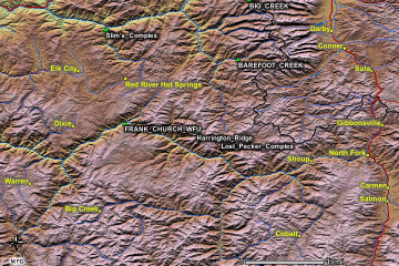
Click on the image above to view a larger JPEG image |
| |
|
Fire Imagery
|
The following color-coded images depict apparent ground surface temperatures
in Celsius. Roads, streams, and the text in the background are from
a 1:24,000 topographic map.
|
| |
|
|
Image 1:
Ground surface temperatures as viewed from above at 11.9
micrometers wavelength on 15 August 2003, at 6:52pm.
|
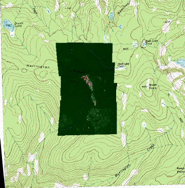
Click on the image above to view a larger JPEG image |
|
Image 1a:
Image from above, on a shaded relief map.
|
Click on the image above to view a larger JPEG image |
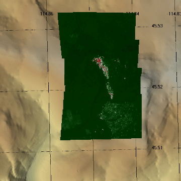
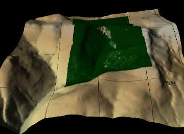
Image 2:
Topographic view as seen from the south of Image 1. |
Click on the image above to view a larger JPEG image |
|
|
|
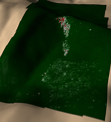
Image 2a:
3D interactive view of Image 2. |
Click on the image above to view a VRML model
(Requires a VRML plugin, such as the Cortona, available here)
|
| |
Helpful hints for 3D viewing-
Click on the 'fit' button (lower right)
to fit the image to your browser window.
For good rotation of the 3D image, set
the 'walk' or 'fly' mode in combination with the 'plan'
movement option to move in closer (using the mouse); then
switch to the 'study' mode and the 'turn' movement option
to rotate the scene (using the mouse).
|
| |
|
| |
|
Narrative
from the INCIDENT MANAGEMENT SITUATION REPORT
SATURDAY AUGUST 16, 2003 - 0800 MDT. (Courtesy of www.nifc.gov.) |
|
HARRINGTON RIDGE, Bitterroot National Forest.
This lightning-caused Wildland Fire Use (WFU) incident, located
65 miles southwest of Darby, MT, is being managed to accomplish
resource objectives. No new information was reported. This
will be the last narrative report unless significant activity
occurs.
|
| |
|
 Piper Navajo remote sensing aircraft


