Hobble
Fire, Sweet Grass County, MT
18 August 2003
As viewed by the FireMapper™
Thermal-Imaging Radiometer
Images were collected from the PSW Airborne
Sciences Aircraft and disseminated in part by satellite
communications in near-real time. FireMapper measures the
radiance of emitted thermal-infrared light, which readily
penetrates smoke. False-color images shown here depict
the apparent surface temperature (in Celsius) as estimated
from
radiance and a simple black-body model. Warmer tones represent
recent or active combustion; areas of gray are cooling
ash
or warm bare ground (see chart below). Low temperatures
of unburned forest and cool ground are shown in green.
Images have been geographically referenced. Vertical exaggeration
in 3-d views is 1.5 to one unless otherwise noted.
|
| |
|
Location Map
Hobble Fire (courtesy of
www.geomac.gov). Active fires are labeled in white. |
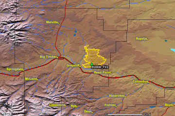
Click on the image above to view a larger JPEG image |
| |
|
Fire Imagery
|
The following color-coded images depict apparent ground surface temperatures
in Celsius. Roads, streams, and the text in the background are from
a 1:24,000 topographic map.
|
| |
|
| Image 1:
Ground surface temperatures as viewed from above at 11.9
micrometers wavelength on 18 August 2003, between 17:21
and 17:32 UMT.
|
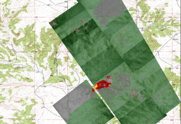
Click on the image above to view a larger JPEG image |
|
Image 2:
Image from above, on a shaded relief map.
|
Click on the image above to view a larger JPEG image |
Image 3:
Topographic view as seen from the northeast of Image 1. |
Click on the image above to view a larger JPEG image
|
|
|
|
| |
|
| |
|
Narrative
from the INCIDENT MANAGEMENT SITUATION REPORT
MONDAY AUGUST 18, 2003 - 0800 MDT. (Courtesy of www.nifc.gov.) |
|
HOBBLE, Southern Land Office, Montana Department
of Natural Resources & Conservation. A
Type 2 Incident Management Team (Larsen) is assigned. This
fire is in timber and grass, six miles
east of Greycliff, MT. This fire was declared contained on
August 16. However, wind gusts of 30
miles per hour caused the fire to jump containment lines.
The fire made significant runs to the
east. Stephens Hill Road is closed and residences along that
road are evacuated. Two
residences and five outbuildings were lost. Structure protection
is in place for eight residences.
|
 Piper Navajo remote sensing aircraft

