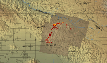
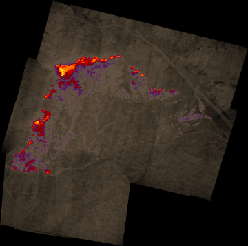
Woodhouse Fire, Riverside County
5 October 2005
As viewed by the FireMapper™
Thermal-Imaging Radiometer
|
Thermal Mosaic
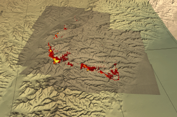
Plan view of fire shown on shaded relief map.

View this image of the Woodhouse Fire as a Google Earth overlay.
|
Click on the image above to view a larger Zoomify image
or view the JPEG version
(opens a new browser window) |
|
Current
Image: Thermal mosaic
Ground surface temperatures as viewed from above at 11.9 micrometers wavelength
on 5 October 2005, at 7:12 to 7:19 pm PDT. |
|
|
|
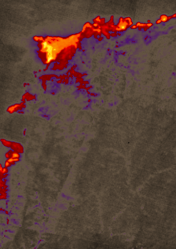
Image 1: Thermal Mosaic
Plan view of fire. |
Click on the image above to view a larger JPEG image
(opens a new browser window) |
|
|
|
Image 1a: Thermal Mosaic
Plan view of fire. |
Click on the image above to view a larger JPEG image
(opens a new browser window) |
|
|
|
Image 2: Mosaic Overlay
Topographic view from west. |
Click on the image above to view a larger JPEG image
(opens a new browser window) |
|
|
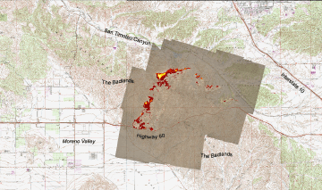
Image 2: Mosaic Overlay
Plan view of fire shown on 1:24k topo map (DRG). |
Click on the image above to view a larger JPEG image
(opens a new browser window) |
Weather conditions at time of data collection:
from NOAA ROMAN system. |
Past Weather Conditions for BNTC1
Observations prior to selected time: October 05, 2005 - 20:00 PDT
Weather Conditions at October 5, 2005 - 19:10 PDT
|
19:10 |
24 Hour Max |
24 Hour Min |
| Temperature |
70.0° F |
80.0 at 16:10 |
64.0 at 5:10 |
| Dew Point |
3.1° F |
14.3 at 20:10 |
-1.2 at 10:10 |
| Wet Bulb Temperature |
44.9° F |
49.4 at 16:10 |
42.7 at 5:10 |
| Relative Humidity |
7% |
12 at 20:10 |
5 at 10:10 |
| Wind Speed |
10 mph from ENE |
17 at 11:10 |
9 at 20:10 |
| Wind Gust |
29 mph |
45 at 13:10 |
26 at 20:10 |
| Pressure |
27.12 in |
27.17 at 9:10 |
27.10 at 17:10 |
| Sea Level Pressure |
29.79 in |
29.86 at 7:10 |
29.72 at 17:10 |
| Altimeter |
29.91 in |
29.96 at 9:10 |
29.88 at 17:10 |
| 1500 m Pressure |
24.96in |
25.00 at 9:10 |
24.93 at 17:10 |
| Solar Radiation |
2.0 W/m*m |
840.0 at 13:10 |
0.0 at 20:10 |
| Fuel Temperature |
68.0° F |
87.0 at 15:10 |
62.0 at 5:10 |
| 10 hr Fuel Moisture |
0 gm |
0 at 20:10 |
0 at 20:10 |
| Battery voltage |
12.30 volt |
13.30 at 9:10 |
12.10 at 6:10 |
|


