USDA Forest ServiceSkip navigational links    
 Pacific Southwest Research Station
 Pacific Southwest
Research Station
 About Us
 Contact Us
 FAQ'S
 Newsroom
 Publications & Products

>500 C

300 C

200 C

80 C

79 C

0 C


Thurman Fire

3 October

30 September

29 September


Pacific Southwest Research Station
800 Buchanan Street
West Annex Building
Albany, CA 94710-0011

(510) 559-6300

 United States Department of Agriculture Forest Service. USDA logo which links to the department's national site. Forest Service logo which links to the agency's national site.


Fire Science: Wildfire Monitoring and Prediction


Fire Imaging: Thurman Fire
Thurman Fire, San Bernardino NF
30 September 2005


As viewed by the FireMapper™ Thermal-Imaging Radiometer

Thermal Mosaic
Plan view of fire shown on shaded relief map (DEM).


Click on the image above to view a larger JPEG image
(opens a new browser window)
Current Image: Thermal mosaic
Ground surface temperatures as viewed from above at 11.9 micrometers wavelength on 30 September 2005, at 4:37 pm PDT.


Fire Imagery


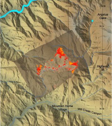
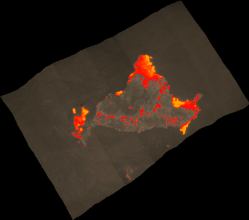
These images depict approximate fireline locations in color-coded pixels of apparent ground surface temperatures in Celsius. Use the map backgrounds as a general location guide, and look for recognizable terrain features or landmarks on the imagery itself for relative positioning of hotspots. Bodies of water, street grids, open fields, highways, ridgelines and stream courses show up well in this imagery.

Images were collected from the PSW Airborne Sciences Aircraft and disseminated in part by satellite communications in near-real time. FireMapper measures the radiance of emitted thermal-infrared light, which readily penetrates smoke. False-color images shown here depict the apparent surface temperature (in Celsius) as estimated from radiance and a simple black-body model. Warmer tones represent recent or active combustion; areas of light gray are cooling ash or warm bare ground and the low temperatures of unburned forest and cool ground are shown in darker gray (see chart above). Images have been geographically referenced. Vertical exaggeration in 3-d views is 1.5 to one unless otherwise noted.


Image 1: Mosaic
Topographic view from northeast.


Click on the image above to view a larger JPEG image
(opens a new browser window)


Image 2: Mosaic
Plan view of fire shown on 1:100k topo map (DRG).


Click on the image above to view a larger JPEG image
(opens a new browser window)


Click on the image above to view a larger Zoomify(JPEG) image
(opens a new browser window)


Archives of past fires: 2008 2007 2006 2005 2004 2003 2002 2001


Forest mapping: 2008 2007 2006 2005 2004 2003 2002 2001


FireMapper™ Specifications: Instrument

FireMapper™ References: Publications

FireMapper™ Tools- image analysis software: ftp downloads page

For Further Information: contact Dr. Philip J. Riggan


FireMapper™ has been developed through a Research Joint Venture with Space Instruments, Inc., and support from the National Fire Plan, Forest Service International Programs, the U.S. Department of Agriculture, the Joint Fire Sciences Program, and the U.S. Agency for International Development.
Disclaimer: Trade names, commercial products, and enterprises are mentioned solely for information. No endorsement by the U.S. Department of Agriculture is implied.
   

Disclaimers | Privacy Policy

 Last Modified: 2005-10-05