|
|
|
 |
Fire Science: Wildfire Monitoring and Prediction
|
|
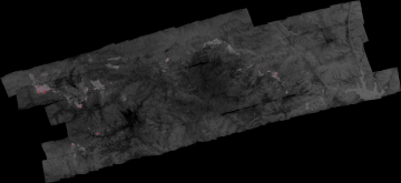
Fire Imaging: Day Fire NORTHERN FLANK ONLY |
|
|
|
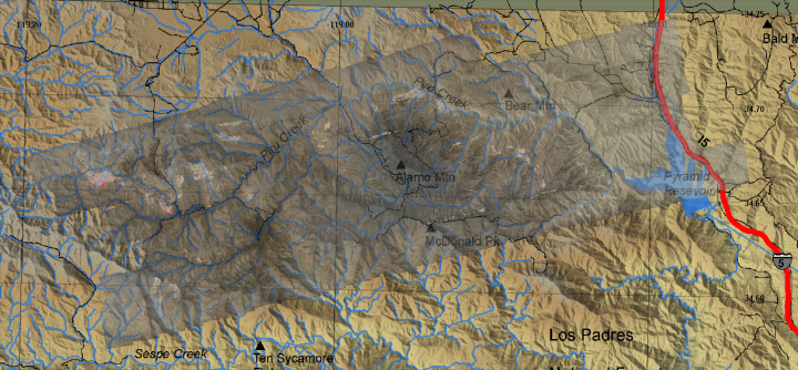
Day Fire, Los Padres & Angeles NF, CA
24 September 2006
As viewed by the FireMapper™
Thermal-Imaging Radiometer
|
|
Click on the image above to view a larger Zoomify(JPEG) image
(opens a new browser window)
Current Image: Thermal mosaic
Ground surface temperatures as viewed from above at 8-12 micrometers wavelength on 24 September 2006, between 20:05 and 21:00 PDT.
|
| |
|
Image 1: Thermal Mosaic
Plan view of fire. Warmer tones represent recent or active combustion; areas of light gray are cooling ash or warm bare ground and the low temperatures of unburned forest and cool ground are shown in darker gray (see chart above).
Purple is used to show very warm ground that may or may not be fire-related. Purple pixels immediately adjacent to red pixels can be interpreted to be cooling ash; purple pixels far from any red pixels may be interpreted as solar heating on bare rock.
This is a portion of the NORTH flank; there are other active firelines that were not recorded during this mission! |
Click on the image above to view a larger JPEG image
(opens a new browser window) |
|
|
|
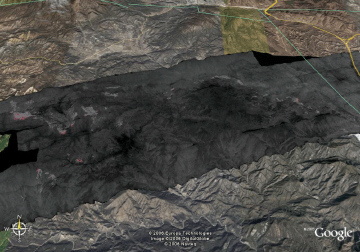
Image 2: Mosaic Overlay
Topographic view from the south.
No vertical exaggeration.

View the Day Fire in Google Earth.
Locations approximate.
|
Click on the image above to view a larger JPEG image
(opens a new browser window) |
|
|
|
| |
ROSE VALLEY
| Temperature: |
56 °F |
| Dew Point: |
24 °F |
| Humidity: |
29 % |
|
|
| Wind: |
SE at 0 MPH |
| Peak Gust: |
11 MPH |
| |
|
| 24 Hour Max/Min Events |
| Max Temperature: |
81 °F |
| Min Temperature: |
56 °F |
| Max RH: |
29 % |
| Min RH: |
10 % |
| Max Dew Point: |
35 °F |
| Min Dew Point: |
10 °F |
| Max Gust: |
22 MPH |
|
|
|
| |
FireMapper™ has
been developed through a Research Joint Venture with Space Instruments,
Inc., and support from the National Fire Plan, Forest Service International
Programs, the U.S. Department of Agriculture, the Joint Fire Sciences Program, and the U.S. Agency
for International Development.
|