>700 C
500 C
300 C
150 C
75 C
45 C
25 C
<25 C
|
 |
Star Fire, Eldorado National
Forest
29 August 2001
As viewed by the FireMapper™
Thermal-Imaging Radiometer
Images were collected from the PSW Airborne Sciences
Aircraft and disseminated in part by satellite communications in
near-real time. FireMapper measures the radiance of emitted thermal-infrared
light, which readily penetrates smoke. False-color images shown
here depict the apparent surface temperature (in Celsius) as estimated
from radiance and a simple black-body model. Warmer tones represent
recent or active combustion; areas of gray are cooling ash or warm
bare ground. Low temperatures of unburned forest and cool ground
are shown in green. Images have been geographically referenced.
Vertical exaggeration in 3-D views is 1.5 to one unless otherwise
noted.
|
|
|
|
|
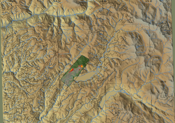
Location map:
Red Star ridge near French Meadows Reservoir
|
Click on the image above to view a larger JPEG image |
|
|
|
|
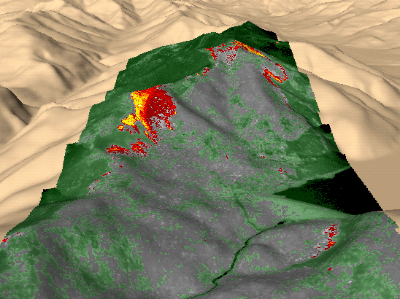
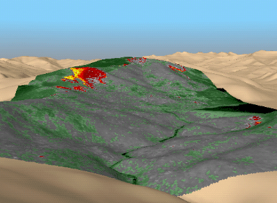
Image 1:
Ground surface temperatures as viewed from the southwest at 14:15
local time. The primary fire run at the left is a crown fire. The
cooler, narrower line at lower right is burning beneath the canopy
of the coniferous forest. Note the reservoir and dam at right and
cool riparian vegetation in the canyon below the dam. Temperature
classes are as shown above.
|
|
|
|
|
|
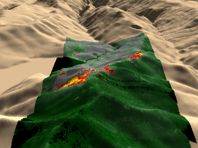
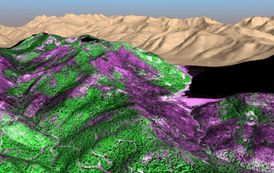
Image 2:
Surface temperatures at 14:15 local time as viewed from the northeast.
|
|
|
|
|
|
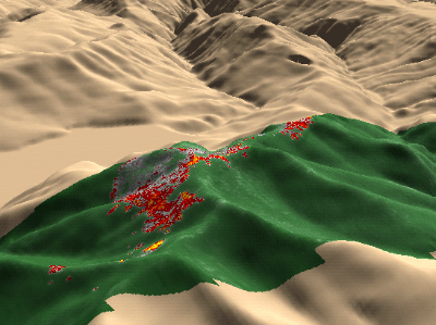
Image 3:
Surface temperatures at 17:52 local time as viewed from the NE.
This is the same view as in Image 2. Note the main fire line has
crossed the ridge at center left and spot fires have grown along
the ridge in the foreground.
|
|
|
|
|
|
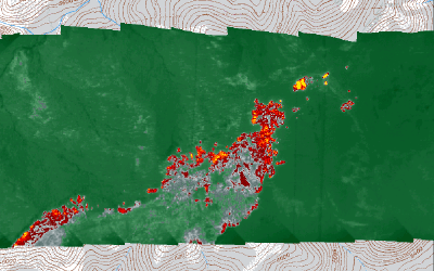
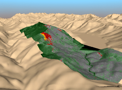
Image 4:
Surface temperatures at 17:52 local time as viewed from above. This
is the same data as shown in Image 3. Map views such as this can
be created to give fire fighters exact coordinates of fire lines
and spot fires and a comparative view of relative fire activity
along different portions of the fire perimeter.
|
|
|
|
|
|
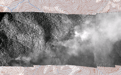
Image 5:
Mosaic of near-infrared light reflected from coniferous forest and
smoke as viewed concurrently with Image 4. Here the obscuring effect
of smoke is shown as a contrast to the fire information available
at thermal-infrared wavelengths.
|
|
|
|
|
|
Image 6:
An air-attack view from the southwest at 14:15 local time shows
the fire as it would appear from the perspective of an aircraft
200 meters above ground level. Generation of such images in nearly
real-time could be useful in showing aircraft approaches and the
relation of fire to terrain for planning actual fire retardant drops
and for training flight crews. (This image has no vertical exaggaration.)
|
|
|
|
|
|
Image 7:
Post-fire, 3-D mosaic of digital aerial photography with reflected
red light shown in magenta and reflected near-infrared light in
green. Shown in this depiction are the resulting ash (with low near-infrared
reflectance) and unburned forest (bright near-infrared reflectance)
as viewed on 27 September 2001. Such data may aid in planning post-fire
emergency rehabilitation of burned watersheds.
|
|
|
|
|
|
Image 8:
Active fire on 29 August 2001 as mapped from thermal-infrared imagery
and a digital elevation model. This view corresponds to the post-fire
scene in Image 7. Note that the crown fire at center-left does indeed
correspond to an area of denuded forest in Image 7. Also compare
the narrow fire line at the right of the dam with the remaining
forest canopy in Image 7.
|
|
|
|
|