>700 C
500 C
300 C
150 C
75 C
45 C
25 C
<25 C
|
 |
Star Fire, Eldorado National
Forest
27 September 2001
As viewed by the FireMapper™
Thermal-Imaging Radiometer
Images were collected from the PSW Airborne Sciences
Aircraft and disseminated in part by satellite communications in
near-real time. FireMapper measures the radiance of emitted thermal-infrared
light, which readily penetrates smoke. False-color images shown
here depict the apparent surface temperature (in Celsius) as estimated
from radiance and a simple black-body model. Warmer tones represent
recent or active combustion; areas of gray are cooling ash or warm
bare ground. Low temperatures of unburned forest and cool ground
are shown in green. Images have been geographically referenced.
Vertical exaggeration in 3-D views is 1.5 to one unless otherwise
noted.
|
|
|
|
Location map:
Red Star ridge near French Meadows Reservoir |
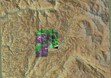
Click on the image above to view a larger JPEG image |
|
Forest Imagery
|
In the following false-color images healthy vegetation appears green and recently killed conifers appear magenta. (These RGB images depict reflected red light at 650 nm in red and blue, reflected near-IR light at 850 nm in green.)
|
|
Image 1: digital aerial photography with reflected red light shown in magenta and reflected near-infrared light in green. Shown in this depiction are the resulting ash (with low near-infrared reflectance) and unburned forest (bright near-infrared reflectance) as viewed on 27 September 2001. Such data may aid in planning post-fire emergency rehabilitation of burned watersheds.
|
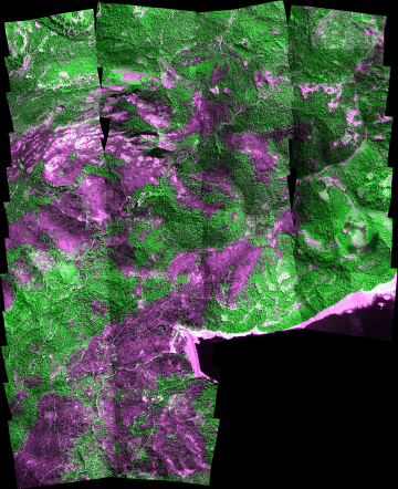
Click on the image above to open a new browser window, then click to zoom in on a portion of that image.
Maximum resolution is 1.5 meters. |
|
|
|
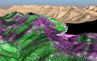
Image 1a:
Post-fire, 3-D mosaic of digital aerial photography with reflected red light shown in magenta and reflected near-infrared light in green. Shown in this depiction are the resulting ash (with low near-infrared reflectance) and unburned forest (bright near-infrared reflectance) as viewed on 27 September 2001. Such data may aid in planning post-fire emergency rehabilitation of burned watersheds. |
|
|
|
|
|
|
|
|
|
|
|
|
|
|
|
|
|
|
|