Fire Spread mapping of the Old Fire, San Bernardino NF
25 October 2003
Set #1, Page 1
As viewed by the FireMapper™
Thermal-Imaging Radiometer
|
Go to Page 2
Go to Page 3
Go to Page 3a
Go to Page 4 |
Images were collected from the PSW Airborne Sciences Aircraft and disseminated in part by satellite communications in near-real time. FireMapper measures the radiance of emitted thermal-infrared light, which readily penetrates smoke. False-color images shown here depict the apparent surface temperature (in Celsius) as estimated from radiance and a simple black-body model. Warmer tones represent recent or active combustion; areas of gray are cooling ash or warm bare ground (see chart below). Low temperatures of unburned forest and cool ground are shown in green. Images have been geographically referenced. Vertical exaggeration in 3-d views is 1.5 to one unless otherwise noted. |
Fire Area Map
|
|
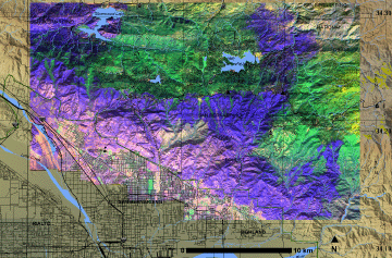
Click on the image above to view a larger JPEG image
(opens a new browser window) |
| |
Fire Imagery
|
The following color-coded images depict apparent ground surface temperatures
in Celsius.
The background image is a portion of a high-resolution
multi-band mosaic assembled from data collected on 9 September
2003 (pre-fire).
|
Flash Movie
|
View these images in sequence as a Flash movie!
Flash viewer required.
Old Fire movie
|
|
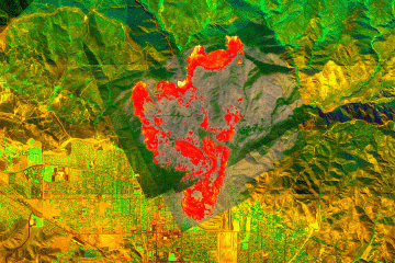
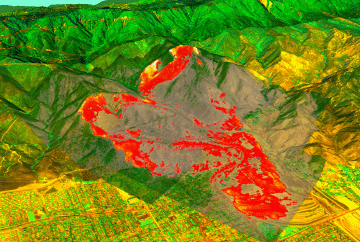
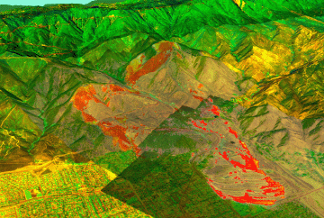
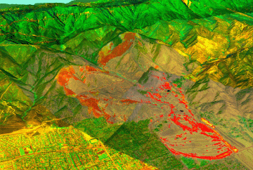
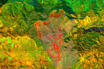
Image 1: Pass 3
Ground surface temperatures as viewed from above at 11.9
micrometers wavelength on 25 October 2003, at 11:09
am PDT.
|
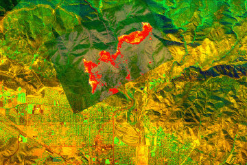
Click on the image above to view a larger JPEG image
(opens a new browser window) |
|
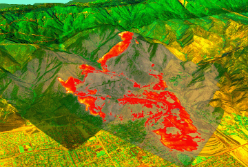
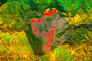
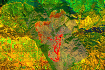
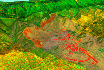
Image 1a: Pass 3
Topographic view from southwest.
No vertical exaggeration. |
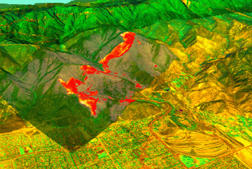
Click on the image above to view a larger JPEG image
(opens a new browser window) |
|
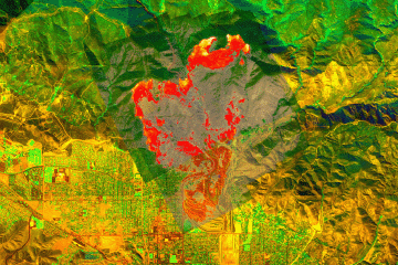
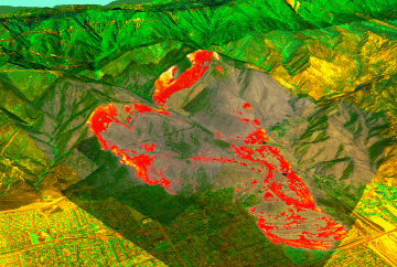
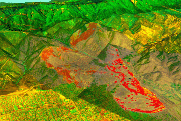
Image 2: Pass 5
Ground surface temperatures as viewed from above at 11.9 micrometers wavelength
on 25 October 2003, at 11:14 am PDT.
|
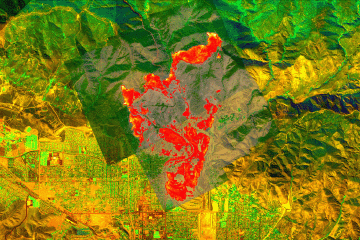
Click on the image above to view a larger JPEG image
(opens a new browser window) |
|
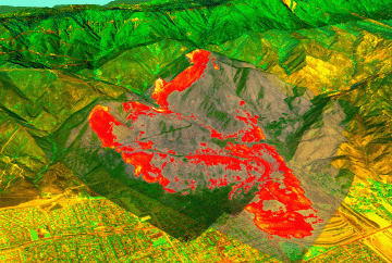
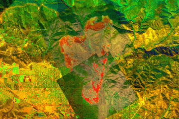
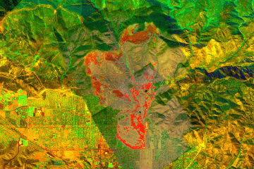
Image 2a: Pass 5
Topographic view from southwest.
No vertical exaggeration. |
Click on the image above to view a larger JPEG image
(opens a new browser window) |
| Image
3: Pass 7
Ground surface temperatures as viewed from above at 11.9 micrometers wavelength
on 25 October 2003, at 11:19 am PDT.
|
Click on the image above to view a larger JPEG image
(opens a new browser window) |
|
Image 3a: Pass 7
Topographic view from southwest.
No vertical exaggeration.
|
Click on the image above to view a larger JPEG image
(opens a new browser window) |
|
Image 4: Pass 9
Ground surface temperatures as viewed from above at 11.9 micrometers wavelength
on 25 October 2003, at 11:24 am PDT.
|
Click on the image above to view a larger JPEG image
(opens a new browser window) |
|
Image 4a: Pass 9
Topographic view from southwest.
No vertical exaggeration.
|
Click on the image above to view a larger JPEG image
(opens a new browser window) |
|
Image 5: Pass 11
Ground surface temperatures as viewed from above at 11.9 micrometers wavelength
on 25 October 2003, at 11:30 am PDT.
|
Click on the image above to view a larger JPEG image
(opens a new browser window) |
|
Image 5a: Pass 11
Topographic view from southwest.
No vertical exaggeration.
|
Click on the image above to view a larger JPEG image
(opens a new browser window) |
|
Image 6: Pass 13
Ground surface temperatures as viewed from above at 11.9 micrometers wavelength
on 25 October 2003, at 11:35 am PDT.
|
Click on the image above to view a larger JPEG image
(opens a new browser window) |
|
Image 6a: Pass 13
Topographic view from southwest.
No vertical exaggeration.
|
Click on the image above to view a larger JPEG image
(opens a new browser window) |
|
Image 7: Pass 14
Ground surface temperatures as viewed from above at 11.9 micrometers wavelength
on 25 October 2003, at 11:43 am PDT.
|
Click on the image above to view a larger JPEG image
(opens a new browser window) |
|
Image 7a: Pass 14
Topographic view from southwest.
No vertical exaggeration.
|
Click on the image above to view a larger JPEG image
(opens a new browser window) |
|
Image 8: Pass 16
Ground surface temperatures as viewed from above at 11.9 micrometers wavelength
on 25 October 2003, at 11:56 am PDT.
|
Click on the image above to view a larger JPEG image
(opens a new browser window) |
|
Image 8a: Pass 16
Topographic view from southwest.
No vertical exaggeration.
|
Click on the image above to view a larger JPEG image
(opens a new browser window) |
|
Image 9: Pass 18
Ground surface temperatures as viewed from above at 11.9 micrometers wavelength
on 25 October 2003, at 12:09 pm PDT.
|
Click on the image above to view a larger JPEG image
(opens a new browser window) |
|
Image 9a: Pass 18
Topographic view from southwest.
No vertical exaggeration.
|
Click on the image above to view a larger JPEG image
(opens a new browser window) |
Go
to Page 2
Go
to Page 3
Go
to Page 3a
Go
to Page 4
|
|
 Piper Navajo remote sensing aircraft
